Intelligent development is becoming more and more mature, AI is in the way, and the Internet infrastructure 2.0 era - AIoT era is coming.
AIoT is the combination of three elements: AI is the brain, the algorithmic ability of continuous advancement, IoT is the shell and backbone, more intelligent terminals, and the industrial Internet needs to define the applications and scenes in the physical space. the AIoT industry landing needs to have the three elements of AI, IoT, and the applications defined by the space in order to define a truly closed-loop, value-landing industry development.

The realization of these three elements, whether "interconnection" or "space", cannot be separated from the support of high-precision positioning. From the personnel positioning terminal cell phones, work cards, helmets and other forms, and then travel to the shared bicycle, motorcycle, scooter, etc., high-precision positioning in the AIoT scenario plays a role in accurate positioning, trajectory tracking, monitoring and management, cost reduction and efficiency.
China Satellite Navigation and Positioning Association recently released the 2022 China Satellite Navigation and Location Services Industry Development White Paper, which shows that the overall output value of China's satellite navigation and location services industry has reached 469 billion yuan in 2021, an increase of 16.29% over 2020. Among them, the core output value of the industry, including chips, devices, algorithms, software, navigation data, terminal equipment, infrastructure, etc., which are directly related to the research and development and application of satellite navigation technology, has increased by 12.28% year-on-year.
From the initial application only in the traditional surveying and mapping industry, to today's penetration into the minutiae of the complex intelligent Internet of things scene, the development of high-precision positioning technology has experienced what important nodes? Let's take a look back~

Principle of high-precision positioning
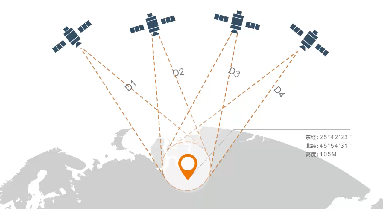
Global navigation and positioning by satellite is based on the principle of airborne triangular backward distance intersection, using the way the satellites send signals to the object, multiplying the one-way signal transmission time with the signal transmission speed to calculate the distance between the object and the satellites. When three satellites send signals to an object at the same time, as long as the individual satellites as the center, respectively, to their respective distances to the object as the radius of the circle, you can determine the object's spatial three-dimensional coordinates at the only intersection. Because of the deviation of satellite star clocks and receiver clocks, four or more satellites are usually required to participate in positioning, and the position accuracy determined in this way is about 5 to 10 meters.

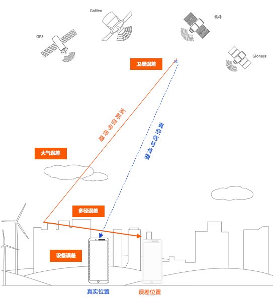
However, various errors in satellite signals passing through the Earth will lead to errors in the calculation of signal propagation time, which in turn will bring about errors in the calculation of distance, thus generating positioning errors of dozens of meters or even more than a hundred meters.
In order to improve positioning accuracy, people build ground-based enhancement stations, and compare the coordinate information of the satellite positioning ground-based enhancement station with the actual coordinate information of the ground-based enhancement station to get the "comprehensive positioning error". High-precision positioning is to broadcast the "comprehensive positioning error" in real time to the terminals within the signal coverage area, and the terminals can take the positioning error into account when positioning by satellite, thus realizing sub-meter or even centimeter-level high-precision positioning.
Service form from single base station to CORS and then to the national network
With the development of high-precision positioning technology, communication technology and satellite positioning equipment, high-precision positioning service has evolved from traditional single-base station differential positioning to provincial CORS positioning service, to the current nationwide ground-based enhancement of a single network, and then through satellite communication technology to broadcast the "integrated error correction number" to achieve global satellite-based enhanced positioning.
In GPS positioning, there are three parts of the error: one is the common receiver error, such as: satellite clock error, ephemeris error, etc.; the second is the propagation delay error, such as: ionospheric error, tropospheric error, etc.; the third is the inherent error of each user's receiver, such as internal noise, channel delay, multipath effect. In order to reduce the impact of these errors on observation accuracy, differential positioning techniques are mostly used.

Single Base Station Differential System
Refers to a GPS receiver placed on the reference station observation, according to the reference station known precise coordinates, calculated the distance from the base station to the satellite and due to the existence of errors in the base station receiver observation of the pseudo-distance between the existence of a difference between the difference (correction value) by the base station in real time to send out, the user receiver in the GPS observation at the same time, but also receive the base station correction number, and positioning results The user's receiver receives the correction from the reference station at the same time as the GPS observation and corrects the positioning result to eliminate the common error. Differential techniques can completely eliminate the first part of the error mentioned above, and can eliminate most of the second part of the error, but cannot eliminate the third part of the error. This technique is widely used because of its ability to improve positioning accuracy.
CORS system
CORS (Continuous Operational Reference System) is a continuously operating reference station system, which means "continuously operating satellite positioning station network and service system". Continuous Operational Reference Station Network for Satellite Positioning (CORS) can be defined as one or a number of fixed, continuously operating GNSS/GPS reference (or datum) stations, utilizing a network composed of computer technology, modern communication technology, data communication and Internet (LAN/WAN), etc., to automatically provide different types of GPS/GNSS reference (or datum) stations of different types and levels to different types of users in real time, and to provide different types of GPS/GNSS reference (or datum) stations of different levels to different types of users in real time. It is a network system that automatically provides different types of verified GPS/GNSS observations (carrier phase, pseudorange), various corrections, status information, and other GPS/GNSS service items to different types, needs, and levels of users in real time. It provides spatial location information services such as dynamic and continuous spatial frame for mobile positioning, and is an indispensable spatial information infrastructure for cities, regions and countries.The operation of CORS has changed the original mode of geodesy to a large extent, and it provides and distributes a series of positioning information to a large number of users by using network and digital communication technology, so that geodesy can serve the construction of the country in a quicker, more extensive, and more direct and open form. National construction.
Ground-based Augmentation System
BeiDou Ground-based Augmentation System (GBS) is an important part of BeiDou Satellite Navigation System (BDSN), which is a major information infrastructure of the country and is used to provide the services of BDSN to enhance the positioning accuracy and completeness. The BeiDou Ground-based Augmentation System consists of a ground-based BeiDou reference station system, a communication network system, a comprehensive data processing system, and a data broadcasting system.
The development and construction of the Beidou Ground-based Augmentation System started in September 2014, and was implemented by the China Satellite Navigation System Administration Office together with the Ministry of Transportation, the Ministry of Land and Resources, the Ministry of Education, the State Administration of Surveying, Mapping and Geoinformation, the China Meteorological Administration, the China Earthquake Administration, the Chinese Academy of Sciences and other departments, in accordance with the principle of "unified planning, unified standards, and common construction and sharing". In accordance with the principles of "unified planning, unified standards, and common construction and sharing", China National Armaments Industry Corporation (CNAMIC) and Thousand Senses Network Corporation (TSNC) are responsible for the construction and operation of the system.
The BeiDou Ground-based Augmentation System is the first of its kind to integrate four types of high-precision services, namely, meter-level, sub-meter-level, centimeter-level and post-processing millimeter-level, within a single system, and there is no precedent at home or abroad to follow.

Ground-based Augmentation Service
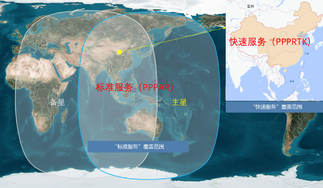
With the continuous development and improvement of the construction of BeiDou ground-based enhancement system, the satellite high-precision positioning technology also develops from traditional RTK technology to network RTK technology and then to PPP-RTK technology. Meanwhile, the ground-based enhancement system relies on the broadcasting of correction numbers by the mobile communication network, so that in the western and northern areas with no network coverage, the users are unable to use high-precision positioning with the integrated error correction numbers that they cannot receive. At this time, the high-precision positioning technology broadcast by satellite communication solves this problem. Meanwhile, by relying on satellite communication broadcasting, the coverage of high-precision positioning service has been extended from the whole country to the whole world.

High-precision Positioning Services and AIoT
High-precision positioning services have been applied only in the traditional surveying and mapping industry from the very beginning - mainly in land surveys, engineering surveys, topographic and geomorphological mapping, and security monitoring, which require centimeter or even millimeter-level positioning accuracy applications. At the same time, traditional surveying and mapping generally use single base station RTK, easy to be plagued by small signal coverage, uneven accuracy within the coverage, temporary base station siting difficult, coordinate reference is not uniform and other problems; to now provide services for various intelligent industry scenarios, especially some of these specific industries, such as shared two-wheeled vehicles, the national a network of high-precision positioning to achieve the box to return the car, the frame can not be returned to the car, effectively help the The operation platform and governmental organizations can effectively assist in the management of shared vehicles.
High-precision positioning terminal form from the traditional measurement and mapping terminal, such as Chance's Star Series, SR Series, to high-precision self-developed module access, in the drone, agricultural machinery, industry wear, two-wheeled vehicles, cell phones, lawnmowers and other intelligent Internet of things industry scenarios application terminal, high-precision positioning algorithms, and the related software and hardware will have more perfect optimization.


