The role of GNSS high-precision positioning in autonomous driving
At the current stage of the automotive field or the field of automated driving, it is not yet a very popular situation. We specialize in deformation monitoring, automated driving of agricultural machinery, and the development of the machinery control market.
Since 2011, we have entered the automated driving of agricultural machinery, that is to say, at that time, we have already modified our Chinese tractors through GNSS technology to realize the automated driving in such a closed environment as farmland, and we have formed a certain scale of application in Xinjiang and the Northeast and other regions.
When we started the independent R&D in 2008, we deeply knew that the independent R&D of antenna is very critical, if there is no independently developed antenna, then many products do not meet the application scenarios, so the shape will be made larger, more bulky, and the performance is also poor.
Since 2008, we have started the independent antenna research and development, and in 2013, we have completely mastered the iteration of independent intellectual property rights antenna, and achieved the self-production of high-precision GNSS antenna. We mainly make breakthroughs in the underlying technology of BeiDou high-precision boards and chips. Therefore, the bottom of the board, chip and GNSS antenna all independent research and development.
In addition, & ldquo; BeiDou ground-based augmentation system & rdquo; we also called GNSS reference station, in the operation and production of a wealth of experience and technical accumulation.

GNSS positioning is a very important factor in the autonomous driving ecology. I will introduce the two aspects of high-precision map and GNSS high-precision positioning, which are a very basic and very important piece of statement information for automatic driving.
High-precision map at this stage is through some post-processing technology, the typical data, picture data and high-precision pos data are closely fused together, and through post-processing, the basic high-precision road network information is formed, which provides the basic map navigation service for the driverless car.
Realizing real-time RTK positioning on a driverless car has relatively high technical requirements. When the driverless car has high-precision location information, it can be matched with the high-precision map, thus forming a good navigation function, which can provide the most basic spatial and temporal information for the sensors in our car for time synchronization or navigation.

The importance of high precision in the field of automatic driving is as follows:
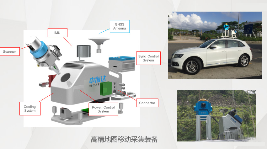
First of all, for high-precision map acquisition, high-precision positioning is a very common sensor in high-precision map acquisition, but it is very important. Through this chart above, you can see the general composition of high-precision map acquisition equipment. Next I split them up and briefly introduce the general principle of composition.
Through this chart can be more intuitive to see the professional high-precision acquisition of the basic composition of the car, GNSS mobile acquisition terminal provides the original GPS data, the original data and then according to the receiving terminal for PPS synchronization, so that high-precision acquisition of the car's camera, IMU, and point cloud lasers and other acquisition equipment to do the time synchronization, so that the trigger of each device are also unified.
When the data is unified, we call this data raw data. At the mobile end, the raw data will be uploaded to the server or given to the map cloud server for processing. At the same time, it is necessary to do high-precision post-processing services on the reference station, so that the Pos information can be corrected with high precision. In this way, the photos, IMUs and point clouds at the mobile acquisition end can get high-precision event information. Finally, a high-precision map is formed by specialized software. This is the principle of high-precision map formation.
Therefore, in the field of autonomous driving, high-precision maps are a very important foundation, because each feature information and attributes need very high-precision data to support, which is equivalent to a ruler of all data, so GNSS accurate positioning can provide more accurate feature attributes for high-precision maps.
These feature attributes can provide better judgment for self-driving cars. Here I listed three aspects to distinguish:
1, the blind area of satellite signals as well as the blocking area of satellite signals;
2, intersection correct lane navigation prediction, advance prediction of special barriers and toll lanes, and locations that provide road signs;
3, providing judgment of blind areas as well as weak areas of mobile communication network coverage.
When the car drives to these areas, the sensors on the car can make some prejudgements based on these attributes provided by the high-precision map, which greatly reduces the pressure of real-time algorithms.
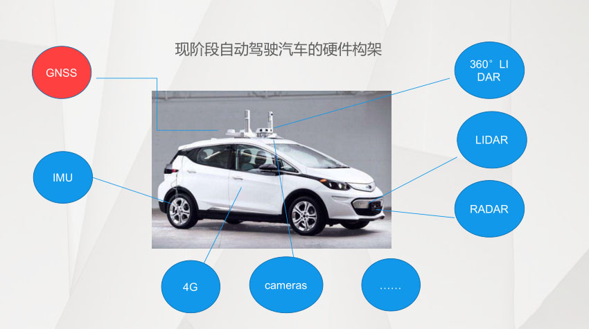
At this stage of the hardware architecture of the self-driving car, GNSS positioning equipment is also essential, GNSS provides real-time high-precision location information, in addition to matching with high-precision maps, will also give a variety of devices time synchronization and event triggering synchronization, which allows all the devices on the self-driving car can be done at a certain point in time to do a certain thing.
High-precision maps are equivalent to the route in the memory of the human brain, that is, the memory of the physical space in the brain, GNSS positioning is equivalent to the human perception of the spatial location and space-time judgment, through the combination of the two so as to know where to go, how to go, and at present, autonomous driving or robots are also in the direction of the development of this direction.
For a self-driving car, think of it as an outdoor fully autonomous robot or a highly intelligent robot. I think the robot is the integration of two major parts, navigation and control, and high-precision positioning just does the navigation part. These navigation and control on the basis of high-precision maps to do a variety of judgments, thus realizing the fully autonomous operation.
The unification of data spatial and temporal benchmarks is the basis of high-precision positioning, which includes high-precision map information and real-time high-precision positioning, and now high-precision positioning are obtained through RTK technology, and RTK positioning technology is a relative positioning technology, so relative positioning must be done to achieve the unity of spatial and temporal benchmarks, otherwise the location of high-precision map information and high-precision real-time positioning of the position is not a match. .
Therefore, our country launched the national 2000 coordinate system a long time ago, and based on this kind of map information as well as high-precision surveying and mapping market map information to do the work of the unified coordinate system, for the future of the automatic driving, automated operation industry to provide spatial and temporal benchmarks.
In short: in the field of automated driving involved in the five spatial and temporal benchmarks necessary factors: GNSS satellites, high-precision maps, the entire territory of the communication network coverage, the entire territory of a unified benchmark of the GNSS base station, the performance of the mobile end of the GNSS receiver, that is, the five major necessary factors for high-precision positioning. It can be seen that GNSS high-precision positioning plays a very big role in automatic driving.


