Explanation of the future development of GPS

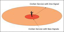
I. The United States is committed to an extensive modernization project that includes the introduction of second and third civil signals for GPS satellites. The second civil signal will increase the accuracy of civil services and improve certain applications related to life safety. The third signal will further enhance the capabilities of civil services, primarily for life safety applications such as aviation.
The figure represents the improvement of the quality of service by the newly added additional signals (figure caption “Conceptual diagram of the performance of a separate GPS plane after the addition of new signals”; down-arrow icon “Civilian service after the addition of the new signals”; up-arrow icon “Civilian service with only one signal”).
GPS began in 1958 as a project of the U.S. military, and was put into use in 1964.In the 1970s, the U.S. Army, Navy and Air Force jointly developed a new generation of satellite positioning system GPS . The main purpose is to provide real-time, all-weather and global navigation services for the three major areas of land, sea and air, and for some military purposes such as intelligence gathering, nuclear explosion monitoring and emergency communications, after more than 20 years of research and experimentation, costing 30 billion U.S. dollars, to 1994, the global coverage rate of up to 98% of the 24 GPS satellite constellation has been laid.

Second, China's Beidou satellite navigation system is ahead of the United States GPS system in terms of navigation and positioning accuracy, reliability and military aspects. The BeiDou-3 navigation system uses tri-frequency signals, while GPS still uses two-frequency signals (it will take several years for all GPS satellites to be replaced by tri-frequency satellites).
BeiDou 3 global positioning system in the military, such as long-range cruise missiles, if only rely on their own inertial system and radar tracking and searching, the error is more than one kilometer, to ensure that the destruction of the target must use more missiles, the cost is high. And after adding the Beidou navigation system, its accuracy can be increased to 10 to 30 meters, a satellite-guided missile can be comparable to the lethality of 20 conventional missiles.
GPS Global Positioning System (Globle Positioning System) is a combination of satellite and communication development technology, the use of navigation satellites for time and distance measurement. It is a new generation of satellite navigation and positioning system with the capability of real-time three-dimensional navigation and positioning on land, sea and air. Characterized by all-weather, high-precision, automation and high efficiency, the Globle Positioning System has been successfully applied to various disciplines such as geodesy, engineering surveying, aerial photography, navigation and control of means of delivery, measurement of crustal movements, engineering deformation surveying, resource surveying and geodynamics, and has achieved good economic and social benefits.


